
Iowa DOT hosts second public forum on future considerations for Black Hawk Bridge; Comment deadline is May 29
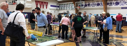
Second open house forum held in regard to future of Black Hawk Bridge ... Officials from the Iowa Department of Transportation (DOT) discuss several plans of action regarding the future of the Black Hawk Bridge crossing the Mississippi River at Lansing at a Tuesday, May 15 open forum meeting with area residents held at Kee High School in Lansing. Public comment is being accepted on the plan proposals until Tuesday, May 29, but DOT officials say that all correspondence received after that deadline date will be included in the project files and reviewed as the project is developed. Comments can be submitted online at http://bit.ly/iowadot2065. Photo by Susan Cantine-Maxson.
by Susan Cantine-Maxson
Tuesday, May 15 at Kee High School in Lansing, area residents attended a second open forum meeting hosted by the Iowa Department of Transportation (DOT) in regard to the potential replacement of the Black Hawk Bridge at Lansing. The first meeting held last August collected opinions about potential designs.
This May 15 meeting had more details about the alternatives under consideration and the issues which need to be addressed in selecting the best alternative. In addition, the DOT wants to be transparent as to what the next steps in this process are.
The DOT and the U.S. Coast Guard conducted simulated barge navigation under the bridge with barge pilots last September. All of this input has been considered in the proposals presented. People attending the meeting left comments during the meeting but online comments are still being accepted until Tuesday, May 29. To submit comments online, go to http://bit.ly/iowadot2065.
Krista Rostad, the Transportation Planner for the Iowa DOT District 2 Office, explained the purpose of the meeting and the ultimate goal of the project: “There are four alternatives which are the same as at last August’s meeting but we have more details and more information about each one of the alternatives. We want people to examine the alternatives and their impacts on properties, cultural, historical and natural environments. The goal is to take the input from comments and evaluate that with the engineering input so that we can narrow it down to two alternatives. We hope to do that by this fall/winter 2018.”
The posters on display at the meeting are also available on the Iowa DOT website at www.iowagov.org/pm under Allamakee Public Meetings. The posters include frequently asked questions, four bridge type alternatives, and the impact these bridges would have in terms of the surrounding areas of their proposed placement.
CONSIDERATIONS FOR NEW BRIDGE
According to DOT officials, a new bridge construction would be considerably wider than the current bridge. The current bridge is approximately 25 feet wide with two 10-foot wide travel lanes and no shoulders. A new bridge would be 40 feet wide with two 12-foot wide travel lanes and an eight-foot wide shoulder on each side of the bridge which could accommodate pedestrians and bicyclists.
The four alternative new construction sites are referred to as the green, blue, purple and orange crossings. The green crossing, which is furthest north, would approach the bridge approximately 2.5 blocks north of the current bridge site.
The blue and purple sites are immediately north approximately half a block (blue) and immediately south approximately half a block (purple) of the current bridge, respectively. All of these three sites would have Highway 9 continue through the downtown area of Lansing along Main Street and then turn up Highway 26, basically following the same approach path as the current bridge but in different locations either up or down the river a bit.
The orange plan deviates the most from the current situation, with Highway 9 bypassing Lansing’s Main Street on the west end of town and following one block south, passing Kee High School, athletic fields, the fire department and several homes. It would cross the river by extending that street to the river and continuing it over the bridge.
All of these bridge approaches would have cement embankments at various approaches to help cut traffic noise. These embankments are shown as red on the diagrams provided at the meeting and also available for viewing online. For new construction, the current bridge would be closed for approximately one month, during which vehicles would need to use alternate routes.
IMPACT TO CURRENT STRUCTURES
The DOT considers a 600-foot wide swath necessary along the proposed pathways of any new bridge construction but actual construction would not impact that wide of an area. Considering this swath, the green, blue and purple sites would impact approximately 30-33 properties and seven businesses while the orange site would impact 57 properties and 16 businesses. The orange plan would impact significantly more acres of wildlife refuge, wetlands, floodplain and recreational areas than the green, blue or purple plan sites.
The bridge designs will be impacted by the location of the bridge, but currently four styles are being considered: an arch bridge and a simple span truss bridge would be the most cost effective, costing approximately $60-$70 million dollars. These designs would look similar to the bridge that is across the Mississippi River at Marquette.
The cable stay bridge and continuous truss bridge also proposed as possible designs would be more expensive choices, ranging from $70-$80 million dollars.
NO-BUILD AND REHABILITATION PROPOSALS
Rostad also explained, “There is also a no-build alternative and rehabilitation alternative, which are required since it is an historic property. While these last two alternatives are being considered, there are implications which need to be realistically considered regarding the standards that must be met for today’s navigation and highway needs.”
The no-build choice would mean that no major renovations would be done and the bridge would close with no replacement if any major problems arise. This alternative does not address any of the major needs of the project. This alternative would cost approximately $1 million with the bridge closing permanently in 2028. Costs for re-routing travelers over alternative routes for the next 100 years (the expected life of a new bridge) would be over $1 billion.
The rehabilitation alternative would involve a major rehabilitation project on the current structure. This rehabilitation would cost more than new construction and would extend the bridge’s life to approximately 2044. The bridge would have to close then with probable new construction cost more than is currently projected because of increases in costs. If the rehabilitation takes place, the bridge would need to close for approximately 18 months for major renovations. It has not been determined as of yet whether rehabilitation will actually address the needs of the overall project.
Rostad continued, “People have also asked if a new bridge is built, could the old bridge be kept as a pedestrian and bicycle path. The short answer is ‘probably not.’ It is not realistic since the DOT would no longer own the bridge and it would be very costly for the City or County to continue the upkeep of the bridge. Every two years there needs to be an inspection which costs around $100,000, plus there would be the maintenance costs. In addition, the Coast Guard wants the bridge piers 100 feet further apart because the current piers are a navigation hazard.”
There are currently no funds allocated for the project. Budgets are projected for approximately five years ahead and this project still has many steps to go through, including more public meetings, plus more specific impact studies as the design gets narrowed down.
Rostad expanded, “We are looking at a 10-year projection. We have to have a preferred alternative, design takes a couple of years, right-of-way acquisition takes a couple of years. A year from now, we would have the preferred alternative where a formal presentation is made. There would also be a right-of-way and design public meeting.
During construction of a new bridge there would be a one-month closure. Also, this fall there will be a minor rehabilitation project which will close the bridge for about a week.”
The next public meeting is planned for the fall/winter of 2018 where the final two alternatives for the bridge project will be explained in more detail. The plan is to review comments and bring back the top two alternatives in the fall/winter of 2018.
Displays from the May 15 meeting may be reviewed at www.iowadot.gov/pm under the Allamakee Public Meeting link. Project Display 1 has 22 pages of pictures and information. Project Display Board 3 shows the purple route, Board 5 shows the orange route and Board 7 shows the green route. There is no individual board for the blue route but Page 21 of Display 1 shows all four proposed sites.