
Black Hawk Bridge in Lansing to be replaced; July 9 meeting shows location, design options
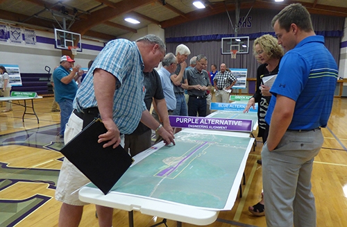
Future plans for the Black Hawk Bridge ... Approximately 135 area residents attended the July 9 public meeting hosted by the Iowa and Wisconsin Departments of Transportation at Kee High School in Lansing to present the latest options for the future of the Black Hawk Bridge in Lansing. Those attending found out plans are to have the bridge replacement underway by 2024, with three different nearby location options, as well as bridge and pier design options, still needing to be decided on as planning continues. Photo by Susan Cantine-Maxson.
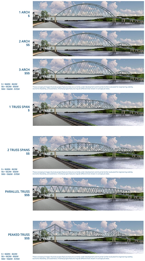
Design options for replacement of Black Hawk Bridge ... Bridge design images courtesy of the Iowa Department of Transportation and Wisconsin Department of Transportation
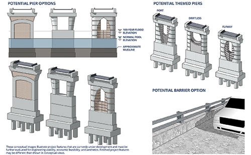
Pier options for replacement of Black Hawk Bridge ... Pier design images courtesy of the Iowa Department of Transportation and Wisconsin Department of Transportation
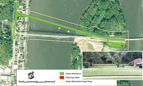
Green location alternative for Black Hawk Bridge replacement ... Located farthest north of the current Black Hawk Bridge location, with inset photo by Susan Cantine-Maxson showing approximate exit/approach location looking west toward North Second Street/Great River Road/Iowa Highway 26 from North Front Street along the Mississippi River. Map image courtesy of the Iowa Department of Transportation and Wisconsin Department of Transportation.
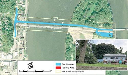
Blue location alternative for Black Hawk Bridge replacement ... Located slightly north of the current Black Hawk Bridge location, with inset photo by Susan Cantine-Maxson showing approximate exit/approach location looking west toward North Second Street/Great River Road/Iowa Highway 26 from North Front Street along the Mississippi River. Map image courtesy of the Iowa Department of Transportation and Wisconsin Department of Transportation.

Purple location alternative for Black Hawk Bridge replacement ... Located slightly south of the current Black Hawk Bridge location, with inset photo by Susan Cantine-Maxson showing approximate exit/approach location looking west toward North Second Street/Great River Road/Iowa Highway 9 from North Front Street along the Mississippi River. Map image courtesy of the Iowa Department of Transportation and Wisconsin Department of Transportation.
Replacement to begin by 2024; Public can comment to DOT by July 22
by Susan Cantine-Maxson
The Iowa Department of Transportation (DOT) and Wisconsin DOT held a public informational meeting at Kee High School in Lansing July 9. Several DOT officials were available at the meeting to answer the public’s questions about the project. A series of display boards explained the processes that have been completed and the future plans, along with options still being considered for location and design elements.
DECISIONS MADE ON SOME OPTIONS
At this point, the DOT has eliminated some of the possibilities for bridge location that had previously been presented. There will be no rehabilitation of the current Black Hawk Bridge, there will not be additions made to the current bridge, and the previously proposed furthest route to the south (the Orange option) which would have rerouted traffic from the bridge along John and Center Streets in front of Kee High School has been eliminated as a location option. The historical and environmental studies of the proposed locations have also now been completed.
DOT officials stated that the only remaining viable option, replacement of the bridge, has been included in its five-year plan, which means it will be scheduled to begin construction for replacement by the end of 2024. The current bridge will remain operational until the new bridge is complete, but there will be some closed time for the bridge when the approaches to the new bridge are being completed no matter which location option is selected, with the current bridge ultimately then being dismantled and removed.
It is anticipated that options will be narrowed as to the placement and style of bridge and support piers by November of this year. The DOT wants as many people as possible to weigh in with comments in regard to their preferences regarding the available options. Additional comments about the lighting of the bridge or other pertinent matters may also be included. Those comments can be made by July 22 on the DOT website, at http://bit.ly/iowadot2723, or by mail to:
Krista Billhorn
Transportation Planner
Iowa DOT
District 2 Office
428 43rd Street SW
Mason City, IA 50401.
TO VIEW OPTIONS AND MAKE COMMENT
All of the informational display boards that were utilized at the July 9 meeting are available on the DOT website as well, http://www.iowadot.gov/pim. At that site, scroll down to the “Iowa 9 Allamakee County – July 9” link to access further links under “Project Displays”. Those display boards show the various design styles of the bridges being proposed, the three possible locations and the style of piers which will support the bridge, all of which are further described below and pictured above.
Of the bridge design choices offered, many in attendance expressed a preference for the peaked truss design which is closest in design to the current structure, since it would have a similar looking profile. Several additional designs are being considered, and public input is very important to the DOT in this regard. The original design choices presented at earlier meetings did not include the peaked truss design, but because so many individuals have expressed concern about losing the iconic look of the current Black Hawk Bridge, it has been added to the possibilities. All seven of those design options can be viewed above and at the “Project display 2” link, including a “$” coding indicating costs ranging between $60 million to $70 million.
Three plans for placement of the new bridge are still under consideration. One route is located directly south of the current bridge (Purple), one route is directly north (Blue) and the third plan is further north by a few hundred feet (Green). Those location options can be viewed above and at the “Project display 3-8” links at the DOT website address listed above.
Pier designs to support the bridge are also under consideration. Currently the piers which support the bridge are plain columns. Piers can be created which are aesthetically more appealing and which would fit into various designs or themes of the area emphasizing the Driftless area, the flyway of the bird migrations or the port of Lansing. Those pier options can be viewed above and at the “Project display 1” link.
Those Project display documents also share further insight into such items as specific reasons for location and rehabilitation options being eliminated. Timelines of the entire planning process are also mapped out, and the consideration process for cultural resources used by the DOT and other agencies throughout the process is also explained in further detail.
NEXT STEPS
The next phase of the project planning is anticipated to span the next 10 months and will include completing further studies and analyses of the design, pier and location options, taking into consideration comments received from the public. The DOT will also continue to coordinate with other involved agencies and work to prepare the necessary Environmental Assessment document. A public hearing is expected to take place in November of this year in Lansing.