
Map clarified for final day of RAGBRAI ...
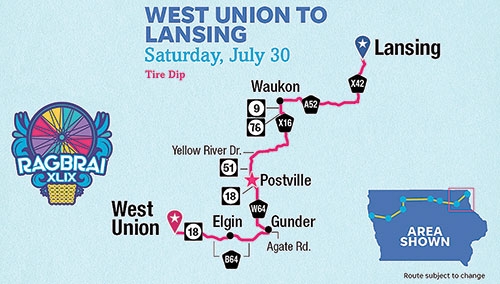
With the announcement made Sunday, March 27 of the complete route of RAGBRAI XLIX that will traverse the state of Iowa July 23-30 this year, the initial map presented by RAGBRAI organizers for the final day of the ride, Saturday, July 30, resulted in some initial questions regarding the actual route, mainly from Postville to Waukon, as far as road names and labels used on the initial map. Inquiries by local authorities resulted in a newly released map by RAGBRAI officials. From the final overnight town of West Union, riders will make their way through Elgin, Gunder, Postville and Waukon on the way to the final tire-dipping destination of Lansing Saturday, July 30, as indicated in the map above. More specifically for Allamakee County, bicyclists will travel north out of Postville on State Highway 51 before taking Yellow River Drive east to County Road X16 (Forest Mills Road), then head north to connect with State Highway 76 and travel into Waukon, where they will connect with County Road A52 (Elon Drive), traveling east to County Road X42 (Lansing Harpers Road) and then north into the route’s final destination of Lansing.