
RAGBRAI® XLV BIKE ROUTE THROUGH ALLAMAKEE COUNTY
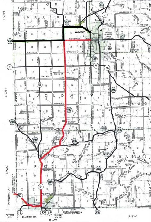
Friday, July 28 route for RAGBRAI® riders (highlighted in red) ... Map courtesy of Allamakee County Emergency Management.
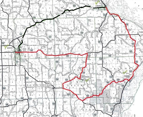
Saturday, July 29 route for RAGBRAI® riders (highlighted in red) ... Map courtesy of Allamakee County Emergency Management.
As most residents of Allamakee County know, the Des Moines Register’s RAGBRAI® XLV bike ride is coming to the county Friday, July 28-Saturday, July 29. As you can imagine, with some 10,000-plus bike riders coming to the county along with the support vehicles that follow along, there will be a “slight” travel and safety impact on the roads they will be using and within the towns they will be passing through and staying in.
Therefore, I wanted to address several safety issues related to RAGBRAI, including the bike route and riders, support vehicles, the community impacts and emergency shelter and response plans being prepared for their safety. My focus for this first RAGBRAI article will be the bike route and its impact on our rural roadway network, with the other topics covered in future publications.
The official RAGBRAI bike routes in Allamakee County have been established and these are the approved roads the riders are supposed to use while making their way through the area. Please understand, some may decide to use other routes, but these would be the exception and against the guidance provided by Des Moines RAGBRAI. The official bike route will be marked and has official ride hours established to help with rider safety and movement. These times are from 6 a.m. to 6 p.m. Friday and 6 a.m. to 4 p.m. Saturday; though be prepared to see some bikes on the routes earlier or later than this.
To ensure rider safety, the bike route will be patrolled by several ambulances and first responder motorcycles provided by Des Moines RAGBRAI in addition to traffic support by the Iowa State Patrol and local law enforcement. This includes several traffic control points to ensure bikes and vehicles safely make their way through various intersections along the route. Additionally, the Iowa Department of Transportation (DOT) will be placing several digital signs along the route to warn drivers of the upcoming RAGBRAI bike traffic as they cross or make their way on the State highways. In addition, there is a plan to place signage at several county road locations to warn traffic of the RAGBRAI routes.
Safety information will also be provided to the riders about being on the county’s roads, especially those with curvy and steep hills and blind corners; to include warning signs posted at several locations. There also could be an impact on our county’s emergency responders' ability to respond at times, and actions and planning are taking place to minimize this as much as possible. In addition, Des Moines RAGBRAI also provides safety information and guidance to the riders.
The public also needs to know that none of the rural bike routes are closed to traffic. However, within all the communities on the route there will be streets closed, with the biggest impacts being within Waukon and Lansing. But, as the bikes make their way through the county the bike routes will become extremely congested during certain times of the day and I would recommend avoiding these, if possible, especially if you have to follow the direction of the route and find yourself going 10 mph at times.
The ride reaches Allamakee County Friday, July 28 on Highway 52 as the riders come from Castalia and make their way into Postville via Highway 18. As they exit Postville, they then make their way north on Highway 51 and then turn right onto Yellow River Drive following this east to Old Stage Road. Turning left and following Old Stage Road north, they will cross over State Highway 9 and then turn right and make their way into Waukon on Old Highway 9 and finish their ride for the day.
After an overnight stay in Waukon, the ride continues Saturday morning as they head east on Elon Drive, making their way to Waterville Road and then into Waterville. Exiting Waterville, the riders continue south on Waterville Road to Highway 76 and then head southeast on the highway itself, turning left onto the State Forest Road and making their way through the Yellow River State Forest to the Lansing Harpers Road. From there, the riders head southeast again to Harpers Ferry and finish the final leg of the route by taking the Great River Road to Lansing and the end of the ride.
Provided with this article are two maps (at left and above) showing the route for Friday and Saturday, with the official bike route shown in red.
Finally, we would ask that you please have patience and understanding as the bikes make their way through the county; this not only helps in keeping the bike riders safe, but you also. So in closing, also consider this as a chance for Allamakee County to show people from all over the United States and even from other countries our beautiful scenery and local hospitality.
Thank you.