
Mississippi River flooding forecasted to reach major stage, second highest ever ...


Water levels on the Mississippi River have been steadily climbing over recent weeks, now to the point of flooding communities along the mighty river, evidence of which can be seen in the photos below along the river valley in Allamakee County from New Albin through Lansing and Harpers Ferry, and on down the river. A combination of record snowfall amounts this year in Minnesota melting so quickly during the unusually warm second week of April, in addition to additional recent snow and rainfall, has caused the Mississippi River to rise more than 10 feet since April 1 from its typical Lansing gauge level hovering above eight feet to its latest measurement as of press time Tuesday morning, April 25 of just over 19 feet, which is considered moderate flood stage, rising nearly six feet within just the past week.
The National Weather Service has forecasted the Mississippi River to continue to rise throughout this week to a possible crest of 20 feet - which would be major flood stage - anticipated sometime this coming weekend before slowly receding, given current weather conditions. That crest would be the second highest river level ever recorded at that Lansing measuring gauge, according to National Weather Service data, second only to the April 1965 record crest of 22.5 feet and surpassing the current second-highest crest of 19.93 feet recorded in April of 2001. National Weather Service data also indicates that at that anticipated 20-foot level Wisconsin Highway 82 (more locally known as the dike road) will be closed to traffic, with South Front Street in Lansing already being closed to traffic as of Monday, April 24 and the Great River Road also anticipated to be closed to traffic south of Lansing as river waters breach those roadways.
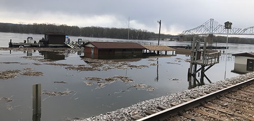
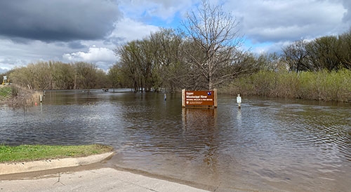
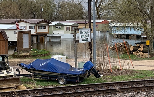
The surrounding photos taken by Julie Berg-Raymond throughout the past weekend show the high water levels at the Lansing Marina nearly engulfing the Tiki Bar (directly at right), as well as river levels approaching the Great River Road south of Lansing (photo directly below) and completely submerging the boat landing located at the east end of the Black Hawk Bridge (photo far below). Further up the river, farm fields typically being prepared for spring planting near the confluence of the Mississippi and Upper Iowa Rivers just south of New Albin are, instead, submerged under the rising river levels (middle photo at right), and further south, the riverside communities in and around Harpers Ferry are also dealing with the brunt of rising water (bottom photo at right), while even further down river, residents of parts of McGregor and Marquette have been evacuated or are preparing for evacuation from their homes.